Derwent Valley – Why Go?
A walk in Derwent Valley lets you enjoy the range of wildlife that thrives in the Peak District National Park. This is certainly one of the best Peak District walks with beautiful countryside scenery and nature-rich landscapes.
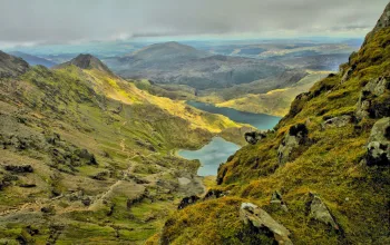
In the farmland and moors, keep your eyes peeled for Golden Plovers and the rare mountain hares, some of the only ones in England. Along this route, you'll also see the beautiful Ladybower Reservoir, and a steep climb through woodland to moorland will reward you with panoramic views of the valley and Dark Peak area.
Derwent Valley – What to Expect
Much of the terrain on this route is rough; you’ll be hiking open fields, moorland, woodland paths, so you’ll need to make sure you have a sturdy pair of walking boots. A decent waterproof jacket wouldn’t go amiss on a hike in the Peaks either – it’s good to be prepared.
If you’re walking this route with your four-legged friend, the National Trust instructs that you keep them on a lead from early March to the end of July so that ground-nesting birds aren’t disturbed. It's also good to avoid walking through large patches of heather during these times so that birds can continue to nest peacefully.
Other walks in this valley include the Derwent Valley Heritage Way route. This trail starts at the Ladybower Reservoir and follows the River Derwent through the Derwent Valley Mills World Heritage Site and Chatsworth. The National Trust recommends using this route when approaching this Derwent Valley walk on foot.
Derwent Valley Walk – The Route, Part 1
5.4km / 1.5 - 2 hours
Starting at Fairholmes car park, turn right and follow the road to Derwent Dam. This dam, and its twin, Howden Dam, were built in the early 1900s, and are famous for a few reasons. They were used for RAF flying practise of the Barnes Wallis bouncing bomb in 1943. The dams also featured in the WWII film, Dambusters.
Pass Derwent Dam and continue on the road, walking uphill with Ladybower Reservoir on the right. Head towards the site of the old Derwent Village, of which only two buildings remain. Pass the schoolroom as you walk along the lane, and take a sharp right at the end of a high wall.
Follow the track over a stile and past the ruins of a farm, walking uphill until the path splits in two after a cottage. Keep left and hike uphill through fields. Climb the stile into the open moorland.
Derwent Valley Walk – The Route, Part 2
Walk through the moorland for about 0.8km (0.5 miles), before turning right by the corner of a wall. The track will level here, passing Pike Low, a Bronze Age burial mound, on your left. Pike Low is situated at the highest point of the moor, and the Peak District mountain hares can sometimes be seen here.
Keep on the path past Pike Low. Mill Brook will be below on your right, and the track runs to the Scots Pine belt, and on towards Green Sitches (sitch meaning a ditch or a wet area). Just before the pines, the path forks. Take the left one and follow the track until it turns right at a fence, which you'll cross with a stile. From here, walk along the edge of the moor towards the old farmstead of Bamford House. Derwent Reservoir will be below you on the left.
When you reach Bamford House, turn left and follow the path down the steep hill towards the reservoir, where you'll turn left again. The track running alongside Derwent Reservoir will take you back to Derwent Dam and the Fairholmes car park where you started the route.
If you like this hike, discover more with our guide to the best Peak District walks.


