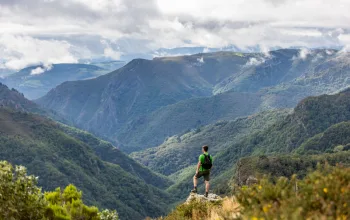
You’re probably the first tourist to climb Mullaghmore,’ says my companion as we reach the summit. ‘We certainly don’t get many of you up this way.’ It’s a perfect day to enjoy this wild, desolate landscape: sunny and clear with a cool breeze. Far off to the east, I can see the shimmering grey waters of Lough Neagh – the UK’s largest lake. I can just make out the imposing silhouettes of the Mourne Mountains to the south, the Donegal highlands in the west and, to the north, the distinct profile of the Antrim Plateau, home to the Giant’s Causeway.
The Sperrins Area of Outstanding Natural Beauty (AONB) consists of a range of hills that straddle the Northern Ireland counties of Londonderry and Tyrone – at 100 square kilometres, it’s one of the largest, yet least visited, upland areas in Ireland. The Sperrins – the name derives from the Irish Na Speiríní, meaning ‘spurs of rock’ – were sculpted by ice from metamorphic rock that formed many millions of years ago. The peaks would once have been much taller, but 12,000–15,000 years ago, an ice sheet sheered off their rough edges to give them their rounded whaleback appearance, while depositing rich glacial deposits in the valley floors.
Although the views across the Sperrins are undeniably impressive, we’ve actually climbed Mullaghmore in search of an unusual landscape feature that Martin Bradley, countryside officer for Strabane Council and part-time walking guide, is keen to show me.
‘I’m big into bogs,’ he says as he strides purposefully through the marshy soil. ‘I studied bogs and sedimentology at university, and I just love to come up here and wander around, seeing all the different shapes in the peat hags. I’m in my own world.’
Rather than being some sort of mystical bog inhabitant, peat hags are erosional features of upland blanket bog that are formed when the surrounding peat has been washed or blown away by heavy rain and strong winds. Usually between one and three metres wide, they resemble large, squat mud-mushrooms, topped off with an unruly mix of grass, moss or heather.
Turfed out
As we explore this bizarre field of peat pinnacles, leaving deep boot prints in our wake, I can’t help wondering if we might be damaging this unusual habitat, which forms a characteristic part of the Sperrins’ landscape. Peat – often referred to in Ireland as turf – is a type of soil that contains a large amount of dead organic matter, accumulated over thousands of years. According to the Northern Ireland Environment Agency (NIEA), it takes about ten years for one centimetre of peat to form; once this happens, it supports a number of rare and unusual plants and animals.
 Ireland’s cool, wet climate is ideal for peat, and several small areas of protected intact blanket and raised bog are found within the AONB, but in the past century, both types of bog have suffered dramatic decline. But it isn’t walkers that are putting them under strain – the Sperrins’ five designated footpaths are never crowded (‘You’ll be lucky if you see another walker,’ says Bradley) – it’s exploitation for fuel.
According to the NIEA, 46 per cent of the blanket bogs and 77 per cent of the raised bogs in Northern Ireland are believed to have, at some point, been cut and re-cut for fuel. ‘You can see the darker areas and the lines on the hills where they’ve cut the peat or blanket bog in the past and taken it down the hill for their turf fires,’ says Bradley.
And in some areas, it’s pretty clear from the muddy scars in the blanket bogs – as well as the lines of plastic bags filled with neatly cut peat – that the practice is ongoing. ‘People still have turbary rights [common or historical rights to cut peat], and at the current time, we’re finding that they’re starting to exploit those again – probably in response to rising oil prices,’ says Ciaran Mullan, nature conservation manager
at the Ulster Wildlife Trust.
A number of measures are in place to prevent unsustainable turf-cutting, and commercial extraction needs consent, but the complexity of land ownership and turbary rights sometimes makes the distinction between commercial and domestic cutting difficult to determine.
Pickled by the peat
When humans first arrived in the Sperrins more than 6,000 years ago, there wouldn’t have been any peat here at all. ‘The first farmers started clearing the land in the Neolithic era,’ says Brendan Gormley, local farmer, historian and part-time guide. ‘When they arrived, it would have been wooded from top to bottom.’
During the Bronze Age, the mountaintops were cleared of trees and became a pastoral landscape primarily used to graze cattle. It was during this time – 1200–1100 BC – that the area experienced a drastic change of climate that helped the first bogs to establish. ‘The climate turned seriously wet, and we know from dendrochronology [tree-ring dating] that there was a period of poor weather that lasted 17 years,’ says Gormley. ‘Growth in the trees was severely stunted and a lot of the upland blanket bogs are believed to have started around then. Once it got a foothold there was no stopping it.’
The expansion of peat over the Neolithic and early Bronze Age landscape sealed the remains of tombs, houses and field walls within the Sperrins bogs. In fact, many have only been discovered due to peat cutting. Driving along the Glenelly Valley in the AONB’s north, Gormley points out the area’s archaeological riches.
‘We’ve just travelled a mile down the road, and in that time we’ve passed numerous Neolithic monuments from around 3500 BC, Bronze Age cist monuments [stone burial chests] from 2500 BC, an early medieval church from about 500 AD, half a dozen raths [medieval fortified farmsteads] from the same era, as well as some farming relics from the past century – lime kilns, lint dams and so on,’ he says. ‘It just goes to show how well used this landscape has been. Today, it seems very desolate and deserted, but it wasn’t always.’
A total of 742 noted monuments lie in the Sperrins, according to Anthony Kirby of the NIEA’s Monuments and Buildings Record. That’s more than seven per square kilometre of the AONB.
 Fairy stories
Before the area’s historical riches became enshrined under various governmental protection measures, folklore and superstition played an important role in conservation, according to Gormley. ‘There were two schools of thought in the Sperrins: “It’s my land and I’ll do what I like with it,” and “I’ll not touch that for nothing – it’s sacred.” And I believe superstition was one of the biggest and most successful methods of preservation.’
Even today, the fear of otherworldly reprisals continues to afford protection over certain features of the Sperrins landscape, most notably the sacred ‘fairy trees’ that accompany many of the area’s ancient monuments. Often a lone rowan, hawthorn or oak tree, fairy trees are easy to spot and widely considered to be sacred – it’s thought to be extremely unlucky to damage one.
Our final stop within the Sperrins is the spectacular Dun Ruadh (‘red fort’), a large circular Bronze Age burial cairn that contains 13 cists located in the heart of the AONB. I stop to admire the old rowan tree right in the centre of the monument that has just come into flower, its gnarled branches extending out over some of the stones.
‘It’s right here in the middle of the stone circle, but even though a branch has fallen off, no-one will touch it,’ says Gormley. ‘It belongs to the fairies – it’s their tree. Man uses almost everything else in the landscape, but there are just a few things that belong to the fairies that we don’t touch – it pisses them off.’
And as I depart the area, the mountains of the Sperrins shrinking away in my rear-view mirror, I can’t help wondering how things might have turned out had the bogs been infused with the same mystical power as the fairy trees.
Local Knowledge - while away your spare time in the sperrins
Best haven for history
‘The Glenelly Valley contains so much hidden history, and every time I go out there – even in the worst of weather – it’s dramatic. There’s so much drama to it – I’m altogether soft on it. But you need to look hard for some of the
best archaeological sites.’ Brendan Gormley, farmer, historian and part time guide
Search for hidden riches
‘There’s gold in these hills – it’s all been reworked by the glaciation, which tore up the ground 20,000 years ago and then deposited it elsewhere. The streams often work out that material, so it comes out at the valley floors along with other minerals, such as corundum and garnet. You would need to be panning for about a year to get enough for a filling, though.’ Martin Bradley, countryside officer at Strabane Council and part-time guide
Be beguiled by blanket bog
‘At first glance, Teal Lough seems bleak and desolate, but this is a fantastic stretch of undisturbed blanket bog that’s teeming with life. At any time of the year, the colours of the bog plants are resplendent, but the heather will be looking its best from late summer through to early autumn.’ Ciaran Mullan, nature conservation manager, Ulster Wildlife Trust
Visit a rare passage tomb
‘In the megalithic tradition, you have court tombs, wedge tombs, portal tombs – they’re all very well represented across the Sperrins. The rarest (I only know of one) is a passage tomb located at Carnanelly. Goles Stone Row, an alignment of 11 stones, points to the summit of the hill where the passage tomb lies.’ Brendan Gormley, farmer, historian and part-time guide
All Images Sperrins Tourism
For more information see www.sperrinstourism.com
This article featured in the July 2009 publication of Geographical magazine


